Browse Listings

Isola del Giapone e penisola di Corea.
A most attractive and decorative map by Vincenzo Coronelli. An elaborate central title cartouche garlanded with intertwined flowers and dedicated to the Rev.de Fontaine o...
Date: Venice, 1692

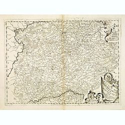
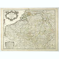
Le comte de Namur et partie des Duchez de Brabant. . .
Decorative map centered on Namen and including the towns of Liege, Leuven, Charleroi, Dinant, Luxemburg, etc. by François Jollain (ca. 1641 – 18 April 1704).Rare "...
Date: Paris, c. 1692
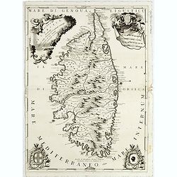
Isola di Corsica, Dedicata all' Em;mo e Rmo: Principe, il Sr. Cardinale Carpegna, Vicario di Sua Santita. . .
One of the most decorative maps of Corsica, with in the upper right, a draped fabric that bears the map's scales is dressed with two angels, one holding the cross, a coat...
Date: Venise, 1692

Oost-Frise, ou Le Comté d'Embden . . .
Fine map of East Friesland with a decorative cartouche and small scale of miles.Alexis-Hubert Jaillot (1632-1712), was a French cartographer. He joined the Sanson heirs a...
Date: Amsterdam, 1692
![Amerique Septentrionale divisée en ses principales parties. . .1692. [California as an Island]](/uploads/cache/27961-250x250.jpg)
Amerique Septentrionale divisée en ses principales parties. . .1692. [California as an Island]
A very good impression of Jaillot's large map of North America, showing California as an Island, based upon Sanson's landmark map of 1656. A first state.The map shows the...
Date: Amsterdam, c.1692
![[Arabia]](/uploads/cache/40143-250x250.jpg)
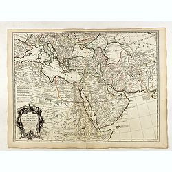
[Arabia]
A lovely miniature map of the region of Armenia and Georgia, showing both parts of the Black Sea and Caspian Sea. For such a small map, it renders a wealth of detail, wit...
Date: Ulm, 1692

Amsterdam Ville du comté de Hollande. . .
A very decorative and very rare town-view of Amsterdam, including a numbered key ( A- T) in the lower part. Engraved by Pierre-Alexandre Aveline. With the signature "...
Date: Paris, ca.1692
Seville ville Archiepiscopale et capitale du Royaume d'Andalousie en Espagne. . .
A very decorative and extremely rare town-view of Seville, including a numbered key ( 1- 37) in lower part. Engraved by Pierre-Alexandre Aveline. With "fait par Avel...
Date: Paris, ca.1692
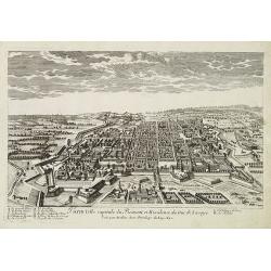
Turin ville capitale du Piémont, et Résidence du Duc de Savoye. . .
A very decorative and rareof Turin, including a numbered key (A-M) in lower part. Engraved by Pierre-Alexandre Aveline. With "fait par Aveline avec privilege du Roy ...
Date: Paris, ca.1692

Mastric ou Maëstricht, Ville du Brabant-Hollandois. . .
A very decorative and extremely rareof Maastricht, including a numbered key (1-23) in lower part. Engraved by Pierre-Alexandre Aveline. With "Fait par Aveline avec p...
Date: Paris, ca.1692

Gouvernement general de Champagne. . .
Fine map of Champagne with a decorative title and scale cartouche.Alexis-Hubert Jaillot (1632-1712), was a French cartographer. He joined the Sanson heirs and redrew Nico...
Date: Amsterdam, 1692

Carte de la Manche. . .
Decorative chart showing the Chanel, with the coastline of France from La Baie de Douarnenez to Dunkerque, and the coastline of England from Stroble head to Manning Tree....
Date: Amsterdam, 1692

Het gezandtschap der Neerlandtsche Oost-Indische Compagnie, aan den grooten Tartarischen Cham, Den tegenwoordigen Keizer van China. . .
Third edition of this beautifully illustrated work on China. The first edition was published in 1665.Jan Nieuhof was a "Dutch traveler and adventurer" (1618-72)...
Date: Amsterdam, W. Waasberge, 1693

ANTIBES, Ville et Port de Mer de Provence, sur la Mer Mediterranée.
Early plan of Antibes. From his "Introduction à la fortification".
Date: Paris, 1693

St Tropez.
Early plan of St.Tropez. From his "Introduction à la fortification".
Date: Paris, 1693

La Basilica Vaticana consacrata al Principe de gli Apostoli . . .
Monumental engraving showing the Papal Basilica of St. Peter in the Vatican, in its setting, with below a coat of arms with dedication to Cardinal Sigismondo Chigi. Obili...
Date: Rome, 1693

Piazza e tempio di Santa Maria della Rotonda gia l'Antico Pantheon.
Monumental engraving showing the Pantheon in Rome, in its setting, with below a ground-plan and elevation. Fountain in front, adjacent buildings and carriages and people ...
Date: Rome, 1693

Le comte d'Artois dresse sur les memoires les plus nouveaux. . .
Map showing the north of France, showing St Omer, and Arras, etc. The map notes Nicolas Sanson as the mapmaker and claims that the map was published by Alexis-Hubert Jail...
Date: Amsterdam, 1693

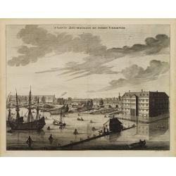
s'Lants Zee-Magazyn en Scheeps Timmer-werf.
Decorative view of the back yard of the formerly the V.O.C. warehouse and arsenal for the Admiralty of Amsterdam, now-a-days the Scheepvaartmuseum (Maritime Museum).The p...
Date: Amsterdam, 1694

Plan de la ville, cite universite et fauxbourgs de Paris comme il est jourddhuy. . .
Detailed town-plan of Paris.Top left and bottom right and left cartouches decorated with views of the top left, Notre Dame, Palace of Orleans, Sorbonne and Val de Grâce,...
Date: Paris, 1694
s'Lants Zee-Magazyn en Scheeps Timmer-werf.
Decorative view of the back yard formerly the V.O.C. warehouse and arsenal for the Admiralty of Amsterdam, now-a-days the Scheepvaartmuseum (Maritime Museum).The print is...
Date: Amsterdam, 1694
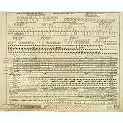
Echelle pour trouver les jours de la semaine. . . / Scale om de Dagen van de Week te vinden. . . / Scale to find the Days of the Week. . .
Fine engraved plate showing eight different scales with explications in French, Dutch and English.Scale om de dagen van de week, de verschietende feest-dagen, de maan-tyd...
Date: Amsterdam, 1695

Parte orientale della China.. / Parte occidentale della China. (2 sheets)
The map depicts the eastern part of China with Korea -correctly- as a peninsula. Formosa is included as well. Japan is partly visible i.e. the area of Yamaguchi, strait K...
Date: Venice, 1695

A plat of the East Sea. By William Fisher and Richard Mount...
An important sea chart of the East Sea with coast lines of Poland, Russia, Sweden, published by William Fisher and Richard Mount in London.Richard Mount (1654-1722) was a...
Date: London, 1695

Prospectus veteris castelli Graviae.
One of the earliest views of the ancient Castle of Grave. Engraved by Casper Bouttats. With a description in Latin, French and Dutch.
Date: Amsterdam, 1695

Prospectus Castelli Boxtel.
One of the earliest views of the Castle of Boxtel. Engraved by Henricus Cause. With a description in Latin, French and Dutch.
Date: Amsterdam, 1695

Vaisseau du premier rang portant pavillon d'amiral.
Fine double-page engraved plate of a naval vessel, with the various parts of the ship numbered and identified. From Mortier's "Neptune François". From Mortier'...
Date: Amsterdam, 1695
Coupe d'une galère avec ses proportions - Quille d'une Galere sur le chantier.
Fine double-page engraved plate of a cutaway of a standard late 17th-century French galley with a detailed legend of parts (in French). Below is a representation of the k...
Date: Amsterdam, 1695

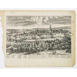
Die Stadt Narva. . .
An early of the town of Narva, located at the eastern tip of Estonia, on the Russian border.From the uncommon Hamburg edition "Viel Vermehrte Moscowitische und Pers...
Date: Hamburg, 1696
![[Title page] Atlas Nouveau contenant toutes les parties du monde . . .](/uploads/cache/49114-250x250.jpg)
[Title page] Atlas Nouveau contenant toutes les parties du monde . . .
Fine title page of classical architectural design incorporating portraits of royalty and battle scenes.
Date: Paris, 1696
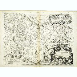
La Transilvania.
A scarce and very attractive detailed map of Transylvania and includes numerous coats of arms in the body of the map and a large decorative title cartouche. Scale cartouc...
Date: Venice, 1696
![Flandra parte occidentale: dedicata all'illustrissimo et eccelententissimo S. Giorgio Cocco, senatore meritissimo. . . [together with] Zelanda e Parte Orientale della Flandra. . . .](/uploads/cache/31286-250x250.jpg)
Flandra parte occidentale: dedicata all'illustrissimo et eccelententissimo S. Giorgio Cocco, senatore meritissimo. . . [together with] Zelanda e Parte Orientale della Flandra. . . .
Wall sized map of two joined sheets of Flanders, the coastline running from Calais to Zeeland in the Netherlands. Including major cities along the coast such as Dunkerque...
Date: Venice, 1696

Isole dell'Indie. . .
A beautiful and flamboyantly engraved large-scale map of the East Indies, including the Malay Peninsula, Cambodia, the Philippines and all of Indonesia and the Spice Isla...
Date: Venice, 1696
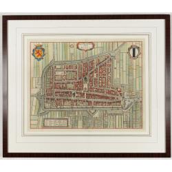
Delfi Batavorum vernacule Delft.
Detailed plan of the city Delft from Frederick de Wit's town book of the Netherlands. The plates are first published by Joan Blaeu one year after the peace of Münster an...
Date: Amsterdam, 1698
Ducato di Luxembourgo . . .
A beautiful and flamboyantly engraved map of Luxembourg. The map is the product of the late 17th century Venetian cartographer, Vincenzo Coronelli. A decorative title car...
Date: Venice, 1698
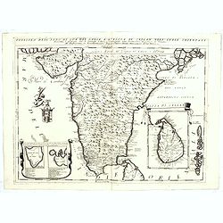
Penisola dell'Indo di qua del Gange, e l isola di Ceilan..
India below the Tropic of Cancer, with an inset of Ceylon and Trincomalee.The remarkable Vincenzo Coronelli (1650-1718), encyclopaedist, geographer, inventor and Doctor o...
Date: Venice, 1698
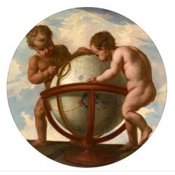
Allegory of geography.
Two putty studying a terrestrial globe, one of them holding a pair of dividers. The information on the globe is clearly imaginary but the two cartouches and ships are typ...
Date: Bruges, ca. 1700
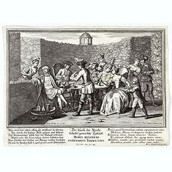
Moris Beneficio Comendatus Tabaci usus. Der durch die Mode beliebt gemachteTaback
Copper-plate engraving showing a group of fashionably dressed men and women smoking long-stemmed pipes around a table in front of a garden hedge. "Paulus Decker inv....
Date: Augsburg, 1700
![[Concert at time of Handel] Dulcissimum Melos Bona Fama.](/uploads/cache/47201-250x250.jpg)
[Concert at time of Handel] Dulcissimum Melos Bona Fama.
Copper-plate engraving of the rehearsal of a chamber cantata by Johann Christoph Steudner, after Paul Decker the elder, in the Handel-Haus, Halle. (Musikgeschichte in Bil...
Date: Augsburg, 1700

Amstelodami celeberrimi hollandiae emporii delineatio nova.
Frederik de Wit’s beautiful bird's-eye view of the city. The Amstel river is still open water flowing through the city's heart. Only near the Dam, has it been covered b...
Date: Amsterdam, c.1700
![[Drawing of a Tulip]](/uploads/cache/06622-250x250.jpg)
[Drawing of a Tulip]
Very detailed and well executed tulip drawing by an unknown artist belonging to the School of Anthony Claesz (1607/8-1649)This drawing was made for a 'Tulip book' painted...
Date: The Netherlands c.1700

Tschopau.
Very decorative and rare panoramic of Tschopau.The engraver and publisher of prints, Mrs. Anna Beek of the Hague, enlarged the print and mounted it on larger paper: she ...
Date: The Hague, ca. 1700

Volna.
Very decorative and rare panoramic town-view of Volna. We have more Anna Beek prints available.The engraver and publisher of prints, Mrs. Anna Beek of the Hague, enlarg...
Date: The Hague, ca. 1700
![[Drawing of a Tulip]](/uploads/cache/06597-250x250.jpg)
[Drawing of a Tulip]
Very detailed and well executed tulip drawing by an unknown artist belonging to the School of Anthony Claesz (1607/8-1649)This drawing was made for a 'Tulip book' painted...
Date: The Netherlands c.1700
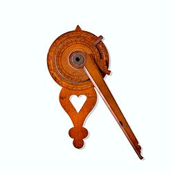
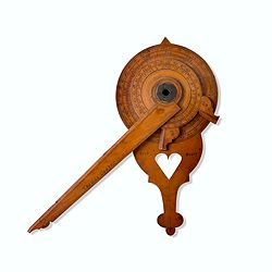
Nocturlabe in boxwood and brass.
Nocturlabe in boxwood and brass, the wheels maintained by a central nut presenting an annual calendar divided into months and days, an hour disc and a mobile alidade, the...
Date: England, ca. 1700

D' Admiralyteyts Huys - La maison de l'Amirauté.
Decorative print of the "D'Admiralyteits Huys", Het Prinsenhof, of the Dutch East India Company VOC. Located at the Oudezijds Voorburgwal 195-199, Amsterdam.
Date: Amsterdam, ca. 1700

Arcenal de l'Amirauté.
A decorative print of the 'T Landts Magazyn , or 'Scheepvaart Museum' (Naval Museum).
Date: Amsterdam, ca. 1700

Novissima Flandriae Comitatus tabula. . .
Rare issue of Theodorus Danckert's attractive map of eastern Belgium provinces, Flanders, with Brugge, Oostende, Gent, Mons, Antwerp, Cambray, etc..Decorative title carto...
Date: Amsterdam, 1700

Oost-Indis Zee Magazyn - Arçenal des Indes Orientalis.
Decorative view of the East Indian Arsenal, now-a-says the Maritime Museum.
Date: Amsterdam, ca. 1700

Chorographia Terrae Sanctae in Angustiorem. . .
Rare. Large visually rich map decorated with illustrations of the sacred objects and places of Judaism. In the bottom center is a plan of ancient Jerusalem, and the route...
Date: Amsterdam, ca. 1700

Tabula Episcopatuum Leodiensis et Coloniensis. . .
Rare issue of Cornelis Danckert's attractive map of Limburg, shows the area of Cologne, Mainz, Trier, Jülich, Mons, Antwerp and Liege in Belgium.Decorative title cartouc...
Date: Amsterdam, 1700
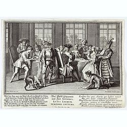
Lusus Lucrum Temporis Iactura.
Copper-plate engraving showing a group of fashionably dressed men and women playing cards. "Paulus Decker inv. et del.; Ioh. Christoph Steudner sculp.; Mart. Engelbr...
Date: Augsburg, 1700

Alssleben.
The engraver and publisher of prints, Mrs. Anna Beek of the Hague, enlarged the print and mounted it on larger paper: she colored it in pastel colors, adding extensive cl...
Date: The Hague, ca. 1700
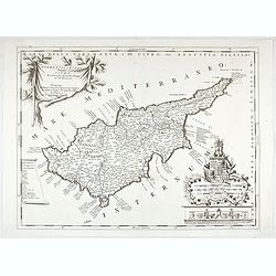
Acamantis insula hogidi Cipro . . .
Decorative map of Cyprus. The remarkable Vincenzo Coronelli (1650-1718), was a Franciscan Friar and appointed General of the Order in 1701. He was cosmographer to the Rep...
Date: Venice, 1700
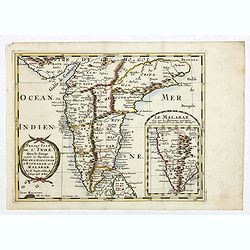
Presqu Isle de L'Inde. deca la Gange.. .
Two maps together on one sheet. General map showing the southern part of India, including the northern part of Shri Lanka. In an inset a detailed map of the most southern...
Date: Amsterdam, 1700
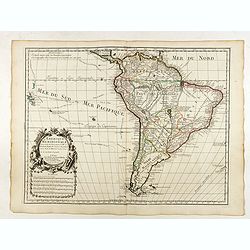
L'Amerique Meridionale Dressée sur les Observations de Mrs de l'Academie Royale des Sciences . . .
Rare state of " L’Amerique Meridionale. Chez l’Auteur sur le Quai de l’Horloge a la Courone de Diamans avec Privilege du Roy pour 20 ans, 1700".Fine map o...
Date: Paris, 1700
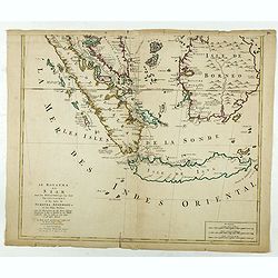
Le Royaume de Siam avec les Royaumes. . .
Influential map of the Malay peninsula, Sumatra, Java and Borneo, centered on Singapore. Mortier incorporated information provided by the French Jesuits and charts the ro...
Date: Amsterdam, 1700

Launa vulgo Laun Bohemiae civitas.
Bird's-eye views of Louny in Bohemia by G. Hoefnagel. The copperplate was made for Braun and Hogenberg's town book. However there the print has been transformed by the en...
Date: The Hague, 1700
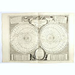
Planisferii Celesti, Calcolati Per L'Anno MDCC, Corretti, Et Aumenati Di Molte Stelle . . .
Double hemisphere celestial map showing a new and more scientific depiction of the heavens. The remarkable Vincenzo Coronelli (1650-1718), was a Franciscan Friar and appo...
Date: Venice, 1700
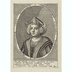
Christophorus Columbus Liguriensis Indiarum Primus Inventor Anno MCCCCXCII.
Portrait of Christopher Columbus (c. 31 October 1451 – 20 May 1506), explorer, colonizer, and navigator, born in the Republic of Genoa, in north-western Italy. Under th...
Date: Antwerp, c.1700
Selling price: ????
Please login to see price!
Sold in 2023
Wooden Nocturnal in boxwood and brass.
This exceptional nocturnal is made of boxwood and brass, the wheels maintained by a central nut, presents an annual calendar divided into months and days, an hour disc,...
Date: England, Thomas Cooper, dated 1701
Carte de la Turquie de l'Arabie et de la Perse.
Very rare state with the address : Chez l’Auteur, Rue des Canettes prez St. Sulpice. Avec Privilège, 1701". This early state with "rue des Canettes" imp...
Date: Paris, 1701

L'Amerique Septentrionale.
Very rare map, from "Metaphaste Barbao, Descriptio Indiae Occidentalis et America Nova" published by Henrico Verdussen.The map is a copy of Guillaume de L'Isle'...
Date: Antwerp, 1702
Carte Des Pays Bas Catholiques Dressée. . .
Rare with the address "Chez l’Auteur sur le Quai de l’Horloge a la Cour. ne de Diamans, 1702. Se trouve à Amsterdam chez L. Renard Libraire près de la Bourse.&...
Date: Paris, 1702
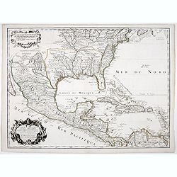
Carte du Mexique et de la Floride.
Third state, with "Quai de l'Horloge" imprint. Renard’s imprint has been erased”. It was the first printed map to portray accurately the course and mouth of...
Date: Paris, 1703
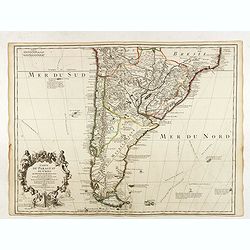
Carte du Paraguay du Chili.
A finely engraved, detailed map of the southern half of South America. Prepared by de l'Isle with the imprint "Chez l’Auteur sur le Quai de l’Horloge avec Privil...
Date: Paris, L. Renard, 1703
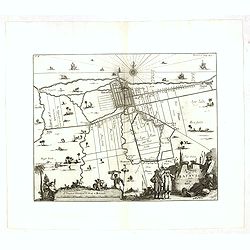
A Mapp of Batavia with all itts Forts.
Wonderful, scarce, and decorative plan of present-day Jakarta, showing the City and its immediate environs, the surrounding rice fields intersected by a network of waterw...
Date: London, Printed for A. and J. Churchill, 1703
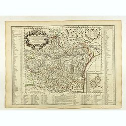
Carte du Diocese de Narbonne.
Topographically detailed map of the Narbonne diocese in southwestern France. Includes major roads and is supplemented with an extensive index. Inset map plan of the forti...
Date: Paris, 1704

Valletta ou Valete ville Forte, de l'Isle de Malta.
A beautifully engraved and richly detailed birds-eye plan of the harbour and city of Valletta seen from the northwest. In lower part extensive key, identifying 57 feautur...
Date: Amsterdam, 1705
Carte du Brabant.
Map of Brabant with the address : Chez l’Auteur sur le Quai de l’Horloge (address erased after Horloge). Avec privilege du Roy. 1705." Guillaume de l'Isle's (167...
Date: Paris, 1705

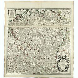
Carte particuliere d'une grande partie des estats situez sur le haut rhein et sur les rivieres qui si déchargent comme sont L'Alsace, la Souabe et la Lorraine,&c. . .
Detailed map of Alsace, Lorraine and Souabe, centered on the River Rhine.
Date: Paris, 1705

Het Friessche Doolhoff, het beruchte dorp Molk-Worren
Uncommon map made in 1718 by Johannes Hilarides, principal at the Latin School in Bolsward.. Probably the only printed plan of a Frisian village of that time. The map was...
Date: Amsterdam, 1705

Horizon ring for globe.
Printed horizon ring for a 28cm diameter German globe. The ring is divided in quarters and engraved two by two on one copper plate. The size of the paper is 44 x 33cm. Th...
Date: Nuremberg, 1704/1705

La mer Mediterranee divisee en ses principales parties ou mers. . .
Very large map centered on the Mediterranean. With a sub title along upper margin "La Mer Mediterranée divisée en Mer de Levant et de Ponant Subdivisées en Leurs ...
Date: Amsterdam, c.1705

La Place de Saint Marc a Venise.
A very attractive Town plan of the place St Marc in Venice.Joan Blaeu published during his life three town books of Italy: Citta del Vaticano, Rome, and Napoli. By the ye...
Date: Amsterdam, 1705
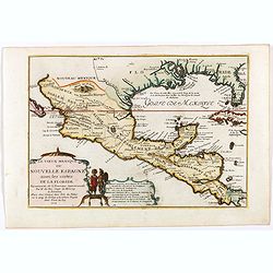
Le vieux Mexique ou nouvelle Espagne. . .
Attractive map covering the Gulf of Mexico through Central America also including parts of Cuba and Jamaica. It extends through Mexico to show the southern tip of Baja Ca...
Date: Paris, 1705
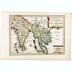
Les Vrays Indes dits Grands Indes ou Indes Orientales Par N. de Fer. Geographe de Sa Majeste Catoliques et de Monseigneur le Dauphin.
Detailed map on India, Thailand, the Malay Peninsular and the south coast of China up to Macao. The map was engraved by C. Inselin.
Date: Paris, 1705
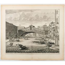
Veue du Pont de Rialto de Venise.
Spectaculair view of Rialto bridge in Venice. Joan Blaeu published during his life three town-books of Italy: Citta del Vaticano, Roma and Napoli. By the year 1672 a fire...
Date: Amsterdam, 1705

LA RUSSIE ROUGE ou POLONOISE qui Comprend les PROVINCES DE LA RUSSIE ROUGE de VOLHYNIE et de PODOLIE divisées en leurs Palatinats Vulgairement Connües sous le Nom D'VKRAINE ou PAYS DES COSAQUES.
A very rare Sanson map of Ukraine and so-called Russie Rouge, stretching from Lublin in the west to Kherson Oblast in the east (here called "Confin de La Petite Tart...
Date: Paris, 1706

Carro, che uà à vela Su le Piagge di Schevelingue.
Italian version of Prince Maurits' sailing carriage designed by Simon Stevin. The big sailing-carriage could seat 28 persons and could reach a speed of seven miles per ho...
Date: Venice, 1707